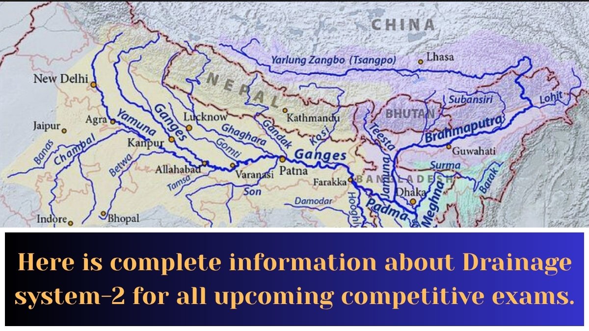
Drainage system-2:Here is complete information about Drainage system-2 for all upcoming competitive exams.
1. River Narmada originates from which place ?
1) Amarkantak
2) Himalaya
3) Brahmagiri
4) Barala Chala pass
Ans:-3) Brahmagiri
• Narmada, also known as Rewa, originates from Narmada Kund on the Amarkantak hill in the Anuppur district of Madhya Pradesh.
• It flows through Madhya Pradesh and Gujarat before finally ending its journey in the Gulf of Khambhat.
• It is the third longest river flowing entirely within India after Godavari and Krishna.
• Sardar Sarovar Project:- This is a joint project of the states of Madhya Pradesh, Maharashtra, Gujarat and Rajasthan. It is built on the Narmada River.
• It was inaugurated on Sept 17, 2017.
———————————————————————
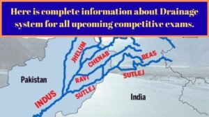
2. Punjab has a large number of inundation canals drawing water from
1) Jhelum river
2) Chenab river
3) Beas river
4) Sutlej River
Ans:-1) Jhelum river
• Punjab has the largest number of canals through the Supplej River.
• These canals provide irrigation mainly during the rainy season when the river is in flood and there is excess water.
• Some such inflow canals are Sirhind, Bhakra, etc.
• Sutlej (R.Sutlej-satadru): It is the most important tributary of the Indus River. It originates in the ‘Rakas Lake’ in the Kailash Mountains of western Tibet. In Tibet it is called Langchen Khambab.
————————————————————————–
3.What is Dakshin Gangotri?
1) River valley in Andhra Pradesh
2) Unmanned station located in Antarctica
3) Second source of River Ganga
4) Island in the Indian Ocean
Ans:-2) Unmanned station located in Antarctica
• South Gangotri is India’s first scientific base station.
• It is located in Antarctica, part of the Indian Antarctic Program.
• Established during 1983-84.
• It is an unmanned station, powered by solar energy, set up using indigenous Indian equipment.
• Situated on the rocks of the mountain range of the Stirmacker Oasis, the alliance was established in 1989. A new station, Bharathi, was established in 2013.
————————————————————————–
4.The region which is a water divide between the Ganga and Indus river systems is
1) Haridwar
2) Namchobarva
3) Alakananda
4) Ambala
Ans:-4) Ambala
• A high land or a mountain like a plateau separates two neighboring drainage basins from each other. This high land is called a water divide. The Ambala region of Haryana acts as a water divide between the Indus River basin and the Ganges River basin.
————————————————————————–
5.Which of the following was not a purpose for building Farakka Barrage?
1) Checking water flowing into Bangladesh
2) Checking silting of Kolkata Port
3) Preventing erosion of Kolkata Port
4) Facilitating navigation in Ganga river
Ans:-1) Checking water flowing into Bangladesh
• India constructed the Farakka Barrage in 1975 to divert water from the Ganges River to the Bhagirathi-Hooghly River system.
• It is designed to check the flow of water to Bangladesh by diverting water from the Ganga-Brahmaputra-Meghna basin.
• In addition, it aims to meet the need for conservation & management of the Kolkata Port by improving the governance and navigation of the Bhagirathi-Hooghly river system. It also aims to reduce erosion of the Calcutta Port.
————————————————————————–
6.Nasik is situated on the bank of the river
1) Mahanadi
2) Tapti
3) Krishna
4) Godavari
Ans:-3) Krishna
• Nashik, also known as the Wine Capital of India or the Napa Valley of India, is located in the Western Ghats of Maharashtra, on the banks of the Godavari River.
————————————————————————–
7.Srinagar is located on the bank of the river
1) Jhelum
2) Indus
3) Chenab
4) Ravi
Ans:- 1) Jhelum
• Srinagar is located in the Kashmir Valley and is on the banks of the Jhelum River, a tributary of the Indus River.
• Jhelum River (R. Jhelum vitasta): The Jhelum River originates in the Pir Panjal range of Kashmir and flows through the Valley of Kashmir and the Wular Lake.
• The present name and original name are given in order: Jhelum-Vitasta, Chenab-Asikini, Ravi-Purushti, Beas-Vipasa, Sutlej-Satudri.
————————————————————————–
8. The river which is used for Inland waterways in India is
1) Ganga
2) Cauveri
3) Mahi
4) Luni
Ans:-1) Ganga
• India has about 14,500 km of navigable waterways.
• This includes the Ganga-Bhagirathi Hooghly rivers, Brahmaputra, Barak river, rivers of Goa, Kerala backwaters, Mumbai inland waters and Godavari Krishna rivers.
• National Waterway 1:- The Allahabad-Haldia waterway of the Ganges-Bhagirathi-Hooghly rivers, with a total length of 1620 km, was declared as National Waterway 1 (NW-1) in 1986.
————————————————————————–
9.Cauvery water sharing is a dispute between
1) Karnataka and Andhra Pradesh
2) Tamil Nadu and Andhra Pradesh
3) Tamil Nadu and Karnataka
4) Karnataka and Maharashtra
Ans:- 3) Tamil Nadu and Karnataka
• Sharing of Cauvery river water is a source of dispute between the Indian states of Karnataka & Tamil Nadu.
• The origin of this conflict lies in two controversial treaties signed between the Madras Presidency and the Mysore Kingdom, one in 1892 and the other in 1924.
————————————————————————–
10. Which one of the following rivers in India has been declared as the National River ?
1) Godavari
2) Krishna
3) Ganga
4) Narmada
Ans:-3) Ganga
• To achieve the objectives of the Ganga Action Plan (GAP), the Prime Minister of India declared the Ganga as a national river on 4 November 2008.
• The Ganges is the largest and most important river in India.
• The 2,500 km long river covers a vast basin of 861,404 km2, covering 26.2 percent of India’s total geographical area.
• Project Dolphin is one of the activities planned under “Artha Ganga”, an ambitious inter-ministerial initiative of the government approved in 2019.
————————————————————————–
11. The world’s highest rail bridge being constructed in the State of J & K will be on which of the following rivers?
1) Jhelum
2) Chenab
3) Indus
4) Ravi
Ans:- 2) Chenab
• Chenab Bridge is an arch bridge under construction in India.
• It spans the Chenab River between Bakkal and Kauri in Reasi district of Jammu and Kashmir.
• Chenab (Asikini) River:- The Chandra and Bhag rivers join near Keidang in Himachal Pradesh and then flow into the Chenab.
• It originates at the Bara Lachha Pass in the Lahaul-Switi region of the Zaskar Range.
• Major projects:- Doolahasti Hydropower Project, Salal Hydropower Project, Baglihar Project.
• The world’s highest railway bridge over this river, at 359 m (above the river water level), has been built in Reasi district of Jammu & Kashmir. It was inaugurated on August 13, 2022.
————————————————————————–
12. Which river flows between the Satpuras and the Vindhyas?
1) Godavari
2) Gandak
3) Tapti
4) Narmada
Ans:- 4) Narmada
• Narmada River:- Narmada is the longest west-flowing river in the Indian subcontinent. It originates at an altitude of 1057 m above sea level in the Mykala range of the Amarkantak plateau of the central highlands.
• It flows westward in a rift valley between the Vindhyas in the north and the Satpura hills in the south. It plunges from a height of 15 m into a deep gorge near Jabalpur, forming the ‘Dhuvandhar’ waterfall.
• The Tapti River and the Mahi River flow through rift valleys.
• This river plunges from a height of 15 m into a deep gorge near Jabalpur, creating the ‘Dhuvandhar’ waterfall.
• Between Handia and Mandhata, there are rapid currents.
• Kapiladhara (23m) and Dhardi Falls (15m) are found near Mandhata Gorge.
• Tapti River:- Narmada, called the twin of the river. Tributaries: Purna, Gira, Panjra, Wafur Bori and Anar Satkala flows in the rift valley of the Ajanta Range and the Satpura Range.
• Mahi River:- Originates in the Vindhya Range of Madhya Pradesh.
————————————————————————–
13. The Idukki hydroelectric plant is on river
1) Godavari
2) Krishna
3) Periyar
4) Tungabhadra
Ans:- 3) Periyar
• Idukki Hydroelectric Power Station is located on the Periyar River in Kerala.
————————————————————————–
14. The River in India known as the open sewer is
1) the Ganga
2) the Yamuna
3) the Narmada
4) the Godavari
Ans:- 1) the Ganga/ 2) the Yamuna
• (1 & 2) The rivers Ganga and Yamuna are called open drainages.
• A substantial population lives on the banks of the Ganges and Yamuna.
• A large amount of waste generated by the population (such as sewage and human waste) is dumped in these.
• Also, industrial waste is discharged directly into these rivers.
• It is contaminated with biochemical oxygen demand (BOD) values ranging from 14 to 28mg1 and high coliform content.
• NOTE:- The Yamuna River is a tributary of the Ganges River.
• Namami Gange is a flagship initiative of the Central Government. It was launched in June 2014 as a national mission for the cleanliness of the Ganga River.
• Main objective:- Conservation and regeneration of the Ganga.
————————————————————————–
15. In ‘annular’ pattern, rivers flow
1) from West to East
2) from North to South
3) like a ring
4) in transverse direction
Ans:- 3) like a ring
• The circular pattern refers to a ring-shaped drainage system.
• Annular pattern: If there are mountain ranges at the edge of a dome-shaped landform, the drainage system there will be circular.
• Furthermore, even though the dome-shaped landform is fragmented, the watercourses there flow in a circular pattern. For example, the Zion River system in the Black Hills of South Dakota and Wyoming, United States.
Read more….


ಉತ್ತಮವಾದ ಪ್ರಶ್ನೆ ಗಳನ್ನು ಎಕ್ಕಿ ತೆಗೆದು ಉತ್ತರವನ್ನು ಸಹ ಅಷ್ಟೇ ಸೊಗಸಾಗಿ ಕೊಟ್ಟ ನಿಮಗೆ ಧನ್ಯವಾದಗಳು ಸರ್
ಉತ್ತಮವಾದ ಪ್ರಶ್ನೆ ಗಳನ್ನು ಎಕ್ಕಿ ತೆಗೆದು ಉತ್ತರವನ್ನು ಸಹ ಅಷ್ಟೇ ಸೊಗಸಾಗಿ ಕೊಟ್ಟ ನಿಮಗೆ ಧನ್ಯವಾದಗಳು ಸರ್
Thank you sir