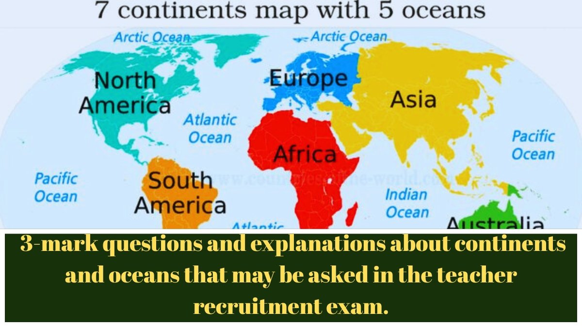
Continents and Oceans: 3-mark questions and explanations about continents and oceans that may be asked in the teacher recruitment exam.
1. Ice glacier’s melting is a common phe nomenon linked to the rise in seawater level. The glaciers are predominantly present in
1) Greenland
2) Antarctica
3) Himalayas
4) Arctic
Ans:- 2) Antarctica
• Glaciers are mainly found in the Antarctic continent,
• This is mainly caused by two phenomena:
1) Global warming and
2) Own depreciation.
• Polar ice caps in Antarctica and other places are melting rapidly, which has led to sea level rise over the years.
• Sea level rise not only inundates land but also submerges islands located in the oceans. This is mainly caused by two phenomena.
—————————————————————————
2. Why is the South Pole colder than the North Pole?
1) High altitude
2) More rainfall
3) Strong winds
4) Away from the sun
Ans:- 1) High altitude
• Both the Arctic (North Pole) and the Antarctic (South Pole) are covered with ice because the direct rays of the sun do not fall on the part.
• The reason the South Pole is colder than the North Pole is because it is built on very thick ice.
• It is located more than 9,000 feet above the ice cap at the South Pole.
• More than a mile and a half above sea level. This altitude makes the South Pole much colder than the North Pole.
—————————————————————————-
3. Which of the following mountain range separates Europe and Asia?
1) Rocky Mountain Range
2) Himalayan Mountain Range
3) Ural Mountain Range
4) Appalachian Mountain Range
Ans:- 3) Ural Mountain Range
• The Ural Mountains are the primary mountain range that divides Europe and Asia.
• (NOTE: All subjects from class 6 to 12 are explained on our YouTube channel)
—————————————————————————–
4. From which of the following continent, all three latitudes i.e. equator, tropic of cancer and tropic of Capricorn pass?
1) North America
2) Asia
3) South America
4) Africa
Ans:- 4) Africa
• Africa is the only continent intersected by the Equator, Tropic of Cancer and Tropic of Capricorn. (Latitude & Longitude diagram is on the next page)
————————————————————————–
5. Alps mountain range is located in which continent?
1) Europe
2) North America
3) South America
4) Africa
Ans:- 1) Europe
• The Alps are the highest and most extensive mountain range found entirely in Europe.
• It stretches for about 1,200 km across eight countries: France, Switzerland, Italy, Monaco, Liechtenstein, Austria, Germany and Poland.
—————————————————————————-
Continents and Oceans: 3-mark questions and explanations about continents and oceans that may be asked in the teacher recruitment exam.
6. What is percentage of expansion (cove rage) of continents on the Earth’s surface?
1) 24-25%
2) 29-30%
3) 33-34%
4) 42-43%
Ans:- 2) 29-30%
• Earth is the fifth largest planet in the solar system in terms of size.
• The total geographical area of the Earth is 510 million square kilometers.
• Of this, 361 million square km (71%) is covered by water and 149 million square km (29%) is covered by land.
• The ratio between land and water is 1:2.43.
—————————————————————————
7. Which one of the following is the continent with the highest mean elevation in the world?
1) Antarctica
2) North America
3) Asia
4) South America
Ans:- 1) Antarctica
• Antarctica:- is an icy continent located at the South Pole of the Earth.
• It is the coldest, driest, and windiest continent in the world. It is called the White Continent because it is completely covered in ice. It has an average elevation of 2300 meters (7545 feet) above sea level, making it the continent with the highest average elevation in the world.
• The elevation of the South Pole in Antarctica is 9300 feet.
• The highest mountain peak in Antarctica is Mount Vinson, which stands at 16,050 feet (5140 meters).
• Indian research stations found in Antarctica:
• South Gangotri (1983) 3 (1988-89)
• India has considered establishing a center called Bharati.
—————————————————————————-
8. Which one of the following factors are responsible for the change in the regular direction of the ocean currents in the Indian Ocean? (UPSC, 1997)
1) Indian Ocean is half an ocean
2) Indian ocean has monsoon drift
3) Indian ocean is a landlocked ocean
4) Indian ocean has greater variations in salinity
Ans:- 2) Indian ocean has monsoon drift
• The Indian Ocean has a monsoon drift.
• Due to the Indian Ocean monsoon, the regular direction of ocean currents changes twice a year, the southwest & northeast monsoon seasons. The following factors are responsible for the change in direction of ocean currents in the Indian Ocean
• India is surrounded on three sides by the Indian Ocean in the south and on the north by a high and continuous mountain-wall.
• Compared to land, water heats or cools more slowly.
• This differential heating of land and sea creates different air pressure zones in and around the Indian subcontinent during different seasons.
• The difference in air pressure causes a reversal in the direction of the monsoon winds.
——————————————————————————-
9. In which continent ‘Great Dividing Range’ is located?
1) North America2
2) South America
3) Asia
4) Australia
Ans:- 4) Australia
• The Great Dividing Range, also known as the East Australian Cordillera or Eastern Highlands.
• This is a cordillera system in eastern Australia, consisting of an extensive collection of mountain ranges, plateaus, and rolling hills. It runs roughly parallel to the east coast of Australia.
• It is the fifth longest land-based mountain chain in the world.
————————————————————————–
10. Which one of the following reflects back more sunlight as compared to other three?
1) Sand desert
2) Paddy crop land
3) Land covered with fresh snow
4) Prairie land
Ans:- 3) Land covered with fresh snow
• Fresh snow and ice reflect about 80-85% of sunlight.
• Snow-covered ice acts like a mirror, reflecting the sun.
• Reflects incoming light.
————————————————————————–
11. Continents have drifted apart because of_______
1) Volcanic eruptions
2) Tectonic activities
3) Folding and faulting of rocks
4) All of the above
Ans:- 2) Tectonic activities
• The continents are separated due to tectonic activities. The continents rest on huge blocks of rock called tectonic plates.
——————————————————————————-
12. Which of the following lake lies on the Equator in Africa continent?
1) Tanganyika
2) Victoria
3) Nyasa lake
4) Lake Kariba
Ans:- 2) Victoria
• Lake Victoria is located on a plateau between the Western & Eastern Rift Valleys. Most of the lake is south of the equator. It is the largest lake in Africa and the main reservoir of the Nile River.
—————————————————————————–
13. How does La-Nina affect the Pacific Ocean?
1) Decreases salinity of ocean
2) Cools downs the temperature of water
3) Maintains stable temperature of water
4) Increases salinity of ocean
Ans:- 3) Maintains stable temperature of water
• La Niña is the opposite of El Niño. It is a cold current that flows from west to east in the tropical Pacific Ocean, thereby cooling the ocean water.
• Lanina means ‘little girl’.
• Since it has the opposite characteristics to the El Nino current, it is commonly called the “Anti El Nino” and sometimes also called the “Old Man”.
—————————————————————————–
14. Which of the following is also known as ‘Doctor winds’?
I. Foehn
II. Harmattan
III. Chinook
1) I and III
2) Only II
3) Only III
4) I and II Both
Ans:- 4) I and II Both
• Harmattan:
• The dry and dusty local wind that blows from the northeast across the Sahara Desert towards the Guinea coast is called the Harmattan.
• The coastal region has a humid equatorial climate with high humidity.
• This dry air from the Sahara modifies and lightens the humid climate. Hence, it is locally called ‘The Doctor’.
—————————————————————————–
15. What is meant by the term “midnight sun”?
1) Twilight
2) Rising Sun
3) Very bright moon
4) Sun shining in the polar circle for long time
Ans:- 4) Sun shining in the polar circle for long time
• The midnight sun is a natural phenomenon in which the sun is visible at local midnight during the summer months in places north of the Arctic Circle and south of the Antarctic Circle.
• Around the solstice (June 21 in the north and December 22 in the south) the sun is visible for a full 24 hours.
• June 21 in the North: Daylight hours increase as latitudes increase north of the equator, i.e. north of the Arctic Circle (66/¾° North latitude).
• The North Pole faces the Sun, so sunsets do not occur north of the Arctic Circle. Therefore, the northern part of Norway (Hammerfest) lies north of the Arctic Circle (66¾° North latitude) and therefore 24 The hour is spent getting sunlight. The sun never sets below the horizon. That’s why Norway is called the ‘Land of the Midnight Sun’.
• During this period, the North Pole faces the Sun for six months, resulting in six months of daylight.
—————————————————————————–